American navigation system. News and analytical portal "electronics time". History of the system development
Determining your location, both on land and at sea, in a forest or in a city, is a question as relevant today as it has been over the past centuries. The era of the discovery of radio waves significantly simplified the task of navigation and opened up new prospects for humanity in many areas of life and activity, and with the discovery of the possibility of conquering outer space, a huge breakthrough was made in the field of determining the coordinates of an object’s location on Earth. To determine coordinates, a satellite navigation system is used, which receives the necessary information from satellites located in orbit.
Now there are two global coordinate determination systems in the world - the Russian GLONASS and the American NavStar, better known as GPS (an abbreviation for the name Global Position System - global positioning system).
The GLONASS satellite navigation system was invented in the Soviet Union back in the early 80s of the last century and the first tests took place in 1982. It was developed by order of the Ministry of Defense and was specialized for operational global navigation of ground moving objects.
The American GPS navigation system is similar in structure, purpose and functionality to GLONASS and was also developed by order of the United States Department of Defense. It has the ability to accurately determine both the coordinates of a ground object and carry out time and speed references. NavStar has 24 navigation satellites in orbit, providing a continuous navigation field over the entire surface of the Earth.
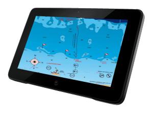
The receiver indicator of a satellite navigation system (GPS navigator or) receives signals from satellites, measures distances to them, and using the measured ranges solves the problem of determining its coordinates - latitude, longitude and, when receiving signals from 4 or more satellites - altitude above sea level , speed, direction (course), distance traveled. The navigator includes a receiver for receiving signals, a computer for processing them and navigation calculations, a display for displaying navigation and service information, and a keyboard for controlling the operation of the device.
These receivers are designed for permanent installation in wheelhouses and instrument panels. Their main features are: the presence of an external antenna and power from an external DC source. They usually have large liquid crystal monochrome screens with alphanumeric and graphic display of information.
:
Compact, waterproof, high performance GPS/DGPS/WAAS receiver designed for small boats. This GPS receiver from the company is capable of receiving and processing additional DGPS/WAAS differential correction signals. This capability allows for accuracy better than 5 meters when receiving corrections from a beacon or WAAS geostationary satellites.
New (D)GPS navigator with built-in differential correction receiver. Path-laying technology allows you to accurately create long-range routes. It is possible to choose a rhoxodromic course (RL) for short distances and an orthodromic course (GC) for long distances.
With path planning technology allows you to accurately create long-distance routes. It is possible to choose a rhoxodromic course (RL) for short distances and an orthodromic course (GC) for long distances.
Fixed receivers have wide functionality, especially professional devices for marine use. They have a large amount of memory, the ability to solve various navigation problems, and their interface allows for inclusion in the vessel’s navigation system.
:
This is a modern receiver indicator of GLONASS/GPS satellite navigation systems designed for vessels of all types.
Developed by specialists of the Radio Complex company using the latest achievements in the field of marine navigation. RK-2006 has the ability to receive signals from already deployed satellite constellations, such as GLONASS and GPS, but also from promising European and Asian positioning systems, this allows, with increased noise immunity and protection from failure of any system, to determine the coordinates of the vessel and its course and speed.
Receiver of global navigation satellite systems GPS and GLONASS, from the South Korean manufacturer of marine radio navigation equipment Samyung ENC Co., Ltd - SGN-500.
When using GLONASS and GPS in combined receivers (almost all GLONASS receivers are combined), the accuracy of determining coordinates is almost always “excellent” due to the large number of visible spacecraft and their good relative position.
Displaying navigation information
GLONASS/GPS receivers use two methods of displaying information: alphanumeric and graphic (sometimes the term “pseudographic” is used).
The alphanumeric method for displaying the received information uses:
- numbers (coordinates, speed, distance traveled, etc.)
- letter combinations that explain digital data - usually abbreviations of phrases (for example, MOV - “Man Over Board” or, in Russian, “Man Overboard!”
- word abbreviations (for example, SPD - speed, TRK - Track), waypoint names. Alphanumeric display of information in its pure form was used at the initial stage of development of GPS technology.
The graphical display method is carried out using pictures formed on the screen, representing the nature of the movement of the carrier (ship, car, person). The graphics in devices from different companies are almost the same and differ, as a rule, in details. The most common designs are:
- electronic compass (not to be confused with magnetic!)
- graphical motion indicator
- traffic route, routes
- symbols for waypoints
- ship coordinates
- direction to waypoint
- speed
Characteristics:
Accuracy of location coordinates
The accuracy of determining the coordinates of a place is a fundamental indicator of any navigation system, the value of which will determine how correctly the ship will follow the laid route and whether it will not hit nearby shoals or rocks.
The accuracy of instruments is usually assessed by the value of the root mean square error (RMS) - the interval in which 72% of measurements fall, or by the maximum error corresponding to 95%. Most manufacturers estimate the standard deviation of their GPS receivers to be 25 meters, which corresponds to a maximum error of 50 meters.
Navigation characteristics
The navigation capabilities of GLONASS/GPS receivers are characterized by the number of waypoints, routes and waypoints contained in them that are stored by the device. By waypoints we mean characteristic points on the surface used for navigation. Modern ones can create and store, depending on the model, from 500 to 5000 waypoints and 20–50 routes with 20–30 points each.
In addition to waypoints, any receiver has a supply of points for recording and saving the route traveled. This number can reach from 1000 to several tens of thousands of points in professional navigators. The recorded route can be used to navigate back along it.
Number of simultaneously tracked satellites
This indicator characterizes the stability of the navigator and its ability to provide the highest accuracy. Considering the fact that to determine two position coordinates - longitude and latitude - you need to simultaneously track 3 satellites, and to determine altitude - four. Modern GLONASS/GPS navigators, even wearable ones, have 8 or 12-channel receivers capable of simultaneously receiving and tracking signals from up to 8 or 12 satellites, respectively.
Today we will talk about what GPS is and how this system works. Let us pay attention to the development of this technology and its functional features. We will also discuss what role interactive maps play in the operation of the system.
History of GPS
The history of the emergence of the global positioning system, or determination of coordinates, began in the United States back in the distant 50s with the launch of the first Soviet satellite into space. A team of American scientists monitoring the launch noticed that as the satellite moved away, it gradually changed its signal frequency. After a deep analysis of the data, they came to the conclusion that with the help of a satellite, in more detail, its location and emitted signal, it is possible to accurately determine the location and speed of movement of a person on earth, as well as vice versa, the speed and location of the satellite in orbit when determining the exact human coordinates. By the end of the seventies, the US Department of Defense launched the GPS system for its own purposes, and a few years later it became available for civilian use. How does the GPS system work now? Exactly the way it worked at that time, according to the same principles and foundations.
Satellite network

More than twenty-four satellites in Earth orbit transmit radio binding signals. The number of satellites varies, but there is always the required number in orbit to ensure uninterrupted operation, plus some of them are in reserve so that if the first ones break down, they will take over their functions. Since the service life of each of them is approximately 10 years, new, modernized versions are being launched. The satellites rotate in six orbits around the Earth at an altitude of less than 20 thousand km, it forms an interconnected network controlled by GPS stations. The latter are located on tropical islands and are connected to the main coordination center in the United States.
How does a GPS navigator work?

Thanks to this network, you can find out your location by calculating the delay of the signal from the satellites, and using this information, determine the coordinates. How does the GPS system work now? Like any spatial navigation network, it is completely free. It works with high efficiency in any weather conditions and at any time of the day. The only purchase you should have is the GPS itself or a device that supports GPS functionality. Actually, the principle of operation of the navigator is based on a long-used simple navigation scheme: if you know exactly the place where the marker object that is most suitable for the role of a landmark is located, and the distance from it to you, draw a circle on which you indicate your location with a dot. If the radius of the circle is large, then replace it with a straight line. Draw several such stripes from your possible location towards the markers; the point of intersection of the lines will indicate your coordinates on the map. The above-mentioned satellites in this case play the role of these marker objects with a distance from your location of about 18 thousand km. Although they rotate in orbit at enormous speed, their location is constantly monitored. Each navigator has a GPS receiver, which is programmed to the desired frequency and is in direct interaction with the satellite. Each radio signal contains a certain amount of encoded information, which includes information about the technical condition of the satellite, its location in Earth's orbit and time zone (exact time). By the way, information about the exact time is the most necessary for obtaining data about your coordinates: the ongoing calculation of the length of time between the release and reception of the radio signal is multiplied by the speed of the radio wave itself, and by short-term calculations the distance between your navigation device and the satellite in orbit is calculated.
Synchronization difficulties

Based on this principle of navigation, it can be assumed that to accurately determine your coordinates, you may only need two satellites, based on the signals of which it will be easy to find the intersection point, and, ultimately, the place where you are. But, unfortunately, technical reasons require the use of another satellite as a marker. The main problem is the clock of the GPS receiver, which does not allow sufficient synchronization with satellites. The reason for this is the difference in time display (on your navigator and in space). The satellites have expensive, high-quality atomic-based clocks, which allows them to count time with extreme accuracy, whereas it is simply impossible to use such chronometers on conventional receivers, since their dimensions, cost, and complexity of operation would not allow them to be used everywhere. Even a small error of 0.001 seconds can shift the coordinates by more than 200 km to the side!
Third marker

So the developers decided to leave the usual technology of quartz watches in GPS navigators and take a different path, to be more precise - to use instead of two satellite landmarks - three, respectively, the same number of lines for subsequent intersection. The solution to the problem is based on an ingeniously simple solution: when all the lines from the three designated markers intersect, even with possible inaccuracies, a zone in the shape of a triangle is created, the center of which is taken as its middle - your location. This also allows you to identify the difference in time between the receiver and all three satellites (for which the difference will be the same), which allows you to correct the intersection of the lines exactly in the center; in other words, this determines your GPS coordinates.
One frequency
It should also be noted that all satellites send information to your device on the same frequency, which is quite unusual. How does a GPS navigator work and how does it perceive all information correctly if all satellites continuously and simultaneously send information to it? Everything is quite simple. To identify themselves, transmitters on the satellite also send standard information in the radio signal, which contains an encrypted code. It reports the maximum characteristics of the satellite and is entered into the database of your device, which then allows you to compare the data from the satellite with the navigator database. Even with a large number of satellites in range, they can be identified very quickly and easily. All this simplifies the entire scheme and allows the use of smaller and weaker reception antennas in GPS navigators, which reduces the cost and reduces the design and dimensions of the devices.
GPS maps
GPS maps are downloaded to your device separately, so you control the terrain you want to navigate. The system just sets your coordinates on the planet, and the function of the maps is to recreate a graphical version on the screen on which the coordinates are plotted, which allows you to navigate the area. How does GPS work in this case? Free, it continues to remain in this status; cards in some online stores (and not only) are still paid. Often, separate applications for working with maps are created for a device with a GPS navigator: both paid and free. The variety of maps is pleasantly surprising and allows you to set up the road from point A to point B as informatively as possible and with all the conveniences: what sights you will pass, the shortest route to your destination, a voice assistant indicating the direction, and others.
Additional GPS equipment
The GPS system is used not only to show you the right path. It allows you to monitor an object that may have a so-called beacon or GPS tracker on it. It consists of a signal receiver itself and a transmitter based on gsm, 3gp or other communication protocols for transmitting information about the location of an object to service centers that carry out control. They are used in many industries: security, medical, insurance, transport and many others. There are also car trackers that connect exclusively to the car.
Travel without problems

Every day the meaning of the map and the permanent compass goes further into the past. Modern technologies allow a person to pave the way for his journey with minimal loss of time, effort and money, while still seeing the most exciting and interesting places. What was science fiction about a century ago has become a reality today, and almost everyone can take advantage of it: from military personnel, sailors and airplane pilots to tourists and couriers. Now the use of these systems for the commercial, entertainment, and advertising industries is gaining great popularity, where every entrepreneur can indicate himself on a global map of the world, and it will not be difficult to find him. We hope that this article has helped everyone who is interested in GPS - how it works, on what principle coordinates are determined, and what its strengths and weaknesses are.
The creation of satellite navigation dates back to the 50s. At the moment when the USSR launched the first artificial Earth satellite, American scientists led by Richard Kershner observed the signal emanating from the Soviet satellite and discovered that, due to the Doppler effect, the frequency of the received signal increases as the satellite approaches and decreases as it moves away. The essence of the discovery was that if you know exactly your coordinates on Earth, then it becomes possible to measure the position of the satellite, and vice versa, knowing exactly the position of the satellite, you can determine your own coordinates.
This idea was realized 20 years later. The first test satellite was launched into orbit on July 14, 1974 by the United States, and the last of all 24 satellites needed to completely cover the earth's surface was launched into orbit in 1993, thus the Global Positioning System, or GPS for short, came into service. It became possible to use GPS to accurately point missiles at stationary and then moving objects in the air and on the ground. Also, with the help of a system built into satellites, it became possible to detect powerful nuclear charges located on the surface of the planet.
Initially, GPS, a global positioning system, was developed as a purely military project. But after a Korean Airlines plane with 269 passengers on board was shot down in 1983, US President Ronald Reagan allowed partial use of the navigation system for civilian purposes. The pitch was reduced by a special algorithm.
Then information appeared that some companies had deciphered the accuracy reduction algorithm and were successfully compensating for this component of the error, and in 2000 this accuracy coarsening was canceled by decree of the US President.
1. Satellite navigation system
Satellite navigation system– a complex electronic technical system, consisting of a set of ground and space equipment, designed to determine the location (geographical coordinates and altitude), as well as movement parameters (speed and direction of movement, etc.) for ground, water and air objects.
1.1 What is GPS?
The GPS satellite navigation system was originally developed by the United States for military use. Another known name for the system is “NAVSTAR”. The name “GPS,” which has already become a common noun, is an abbreviation for Global Positioning System, which translates as Global Navigation System. This name fully characterizes the purpose of the system - providing navigation throughout the entire globe. Not only on land, but also at sea and in the air. Using GPS navigation signals, any user can determine their current location with high accuracy.
This accuracy was largely made possible thanks to the steps of the American government, which in 2000 made the GPS system accessible and open to civilian users. Let us recall that previously, using a special selective access mode (SA - Selective Availability), distortions were introduced into the transmitted signal, reducing the positioning accuracy to 70-100 meters. Since May 1, 2000, this mode has been disabled and accuracy has increased to 3–10 meters.
In fact, this event gave a powerful impetus to the development of household GPS navigation equipment, reducing its cost, and actively popularizing it among ordinary users. Currently, GPS receivers of various types are actively used in all areas of human activity, from ordinary navigation to personal control and exciting games such as “ Geocaching" According to the results of many studies, the use of GPS navigation systems provides a great economic effect for the global economy and the environment - traffic safety increases, the road situation improves, fuel consumption decreases, and the amount of harmful emissions into the atmosphere decreases.
The growing dependence of the European economy on the GPS system, and, as a result, on the US administration, forced Europe to begin developing its own navigation system - Galilleo. The new system is similar in many ways to the GPS system.
2. Composition of the GPS system
2.1 Space segment
The space segment of the GPS system consists of an orbital constellation of satellites emitting navigation signals. The satellites are located in 6 orbits at an altitude of about 20,000 km. The orbital period of the satellites is 12 hours and the speed is about 3 km/s. Thus, every day, each satellite makes two full revolutions around the Earth.
The first satellite was launched in February 1978. Its size with open solar panels was 5 meters, and its weight was more than 900 kg. This was the satellite of the first modification of GPS-I. Over the past 30 years, several modifications of GPS satellites have changed in orbit: GPS II-A, GPS II-R, GPS IIR-M. During the modernization process, the weight of the satellites was reduced, the stability of the on-board clocks improved, and reliability increased.
GPS satellites transmit three navigation signals on two frequencies L1 and L2. The “civilian” C/A signal, transmitted on the L1 frequency (1575.42 MHz), is available to all users and provides positioning accuracy of 3–10 meters. High-precision “military” P-code is transmitted at frequencies L1 and L2 (1227.60 MHz) and its accuracy is an order of magnitude higher than the “civilian” signal. The use of a signal transmitted at two different frequencies also makes it possible to partially compensate for ionospheric delays.
The latest modification of the GPS IIR-M satellites implements a new “civilian” L2C signal, designed to increase the accuracy of GPS measurements.
Identification of navigation signals is carried out by a number corresponding to a “pseudo-noise code”, unique for each satellite. The technical specification of the GPS system initially contained 32 codes. At the stage of development of the system and the initial period of its operation, it was planned that the number of working satellites would not exceed 24. Free codes were allocated for new GPS satellites at the commissioning stage. And this amount was enough for the normal functioning of the system. But at present, there are already 32 satellites in orbit, of which 31 are operating in operating mode, transmitting a navigation signal to Earth.
The “redundancy” of satellites allows the user to calculate the position in conditions where the “visibility” of the sky is limited by high-rise buildings, trees or mountains.
2.2 Ground segment
The ground segment of the GPS system consists of 5 control stations and a main control station located at US military bases - on the islands of Kwajalein and Hawaii in the Pacific Ocean, on Ascension Island, on Diego Garcia Island in the Indian Ocean and in Colorado Springs, they transferred to Figure 1.The tasks of monitoring stations include receiving and measuring navigation signals coming from GPS satellites, calculating various types of errors and transmitting this data to the control station. Joint processing of the received data makes it possible to calculate the deviation of satellite trajectories from given orbits, time shifts of on-board clocks and errors in navigation messages. Monitoring the status of GPS satellites occurs almost continuously. “Downloading” of navigation data, consisting of predicted orbits and clock corrections for each of the satellites, is carried out every 24 hours, at the moment when it is in the access zone of the control station.
In addition to ground-based GPS stations, there are several private and government tracking networks that measure GPS navigation signals to determine atmospheric conditions and satellite trajectories.
Picture 1
2.3 User equipment
User equipment refers to navigation receivers that use signals from GPS satellites to calculate the current position, speed and time. User equipment can be divided into “household” and “professional”. In many ways, this division is arbitrary, since sometimes it is quite difficult to determine which category a GPS receiver should be classified into and what criteria to use. There is a whole class of GPS navigators used for hiking, car travel, fishing, etc. There are aviation and marine navigation systems, which are often part of complex navigation systems. Recently, GPS chips have become widespread and are integrated into PDAs, phones and other mobile devices.
Therefore, in navigation O The division of GPS receivers into “code” and “phase” has become more widespread. In the first case, information transmitted in navigation messages is used to calculate the position. Most inexpensive GPS navigators, costing $100–2000, fall into this category.
The second category of GPS navigation receivers uses not only the data contained in navigation messages, but also the phase of the carrier signal. In most cases, these are expensive single- and dual-frequency (L1 and L2) geodetic receivers capable of calculating position with a relative accuracy of several centimeters and even millimeters. This accuracy is achieved in RTK mode, when jointly processing GPS receiver measurements and base station data. The cost of such devices can be tens of thousands of dollars.
3. Work GPS navigator A
The basic principle underlying the entire GPS system is simple and has long been used for navigation and orientation: if you know the exact location of something reference point and the distance to it, then you can draw a circle (in the 3-dimensional case, a sphere) on which the point of your position should be located. In practice, if the above distance, i.e. radius is large enough, then you can replace the arc of a circle with a straight line segment. If you draw several such lines corresponding to different reference points, then the point of their intersection will indicate your location. In GPS, the role of such reference points is played by two dozen satellites, each moving in its own orbit at an altitude of ~ 17,000 km above the Earth’s surface. The speed of their movement is very high, but the orbital parameters and their current location are known with high accuracy to the on-board computers. An important part of any GPS navigator is a conventional receiver operating at a fixed frequency and constantly “listening” to the signals transmitted by these satellites. Each of the satellites constantly emits a radio signal, which contains data about the parameters of its orbit, the state of on-board equipment and the exact time. Of all this information, data on the exact on-board time is the most important: the GPS receiver, using the built-in processor, calculates the time interval between sending and receiving the signal, then multiplies it by the speed of propagation of radio waves, etc. finds out the distance between the satellite and the receiver.
Perhaps today there is not a single person leading an active life who does not know about the existence of GPS navigators. Over the past few years, these devices have evolved from an expensive car toy to a reliable and indispensable travel companion. Technological progress has flooded the markets with such systems to such an extent that now anyone can test in action what a GPS navigator is, finding a model that suits their needs and financial capabilities.
Undoubtedly, almost every motorist is familiar with the situation when you simply cannot do without a map on the road. Now road atlases are receding into the background, and it makes sense to carry them with you only as a reserve - just in case (if the electronics fail).
Why do you need a GPS navigator?
The main function of a GPS navigator is to determine your exact location. On the color monitor it will show a detailed map of the area, streets, addresses of stores, gas stations, attractions and other objects necessary for the motorist. In addition, the device will select the optimal route and even guide you along it, warning you of possible obstacles along the way. Missed the right turn? No need to panic! The car GPS navigator will quickly calculate and indicate an alternative route to your destination. And to prevent the driver from being distracted, almost every development in recent years has a voice interface that warns in Russian about an upcoming turn or route change.
Main functions
 If your GPS navigation device is equipped with a function for analyzing information about traffic flows and traffic congestion, then you are guaranteed the opportunity to best avoid road obstacles. This is especially useful when crossing unfamiliar cities.
GPS navigator makes driving at night easier. It warns in advance of every upcoming turn, bend and incline, allowing the driver to react in time to changes in road terrain.
One of the serious problems when driving on a high-speed unfamiliar highway is the preliminary selection of a lane for the subsequent exit in the right direction. A perfect GPS navigator will easily tell you where and into which lane you should change lanes.
Another unique ability of a GPS navigator is the ability to see road signs and warn about their presence in time. So an unpleasant meeting with the traffic police can be avoided if any important sign is accidentally left unnoticed by you.
What's better?
Many people often ask the question: “Why buy a car GPS navigator if my mobile phone (communicator) already has all the functions for communicating with a satellite?” The question is quite appropriate, considering that it is asked, as a rule, by people who have never driven.
The main advantage of a separate car navigator is ease of use thanks to the large screen. Agree that looking at the road with one eye and peering at a five-inch smartphone with the other is not entirely comfortable, and even unsafe. It’s nice to hear caring prompts from your answering machine, but it’s much better to visualize the picture of the path clearly, when you can see where you are and what lies ahead. The touch interface allows you to control the program by sliding your finger across the screen without taking your eyes off it. Of course, modern communicators and personal digital assistants (PDAs) also have this capability. And everything would be fine if it weren’t for the small screen and the weakly sensitive GPS module.
The sensitive GPS receiver with a powerful antenna built into the car navigator allows you to more reliably receive signals from the satellite along the entire route.
 The heart of the car navigator is a modern processor specially designed for such systems (SIRFatlas) and maximally optimized for the analysis of satellite navigation signals. And this, in turn, allows you to process more capacious information, displaying on the screen such small details of the area that the mobile phone processor cannot decipher.
Additional features
The latest generation car navigators can act as a CCTV camera monitor, as well as a TV screen for watching satellite television. The sound output can be connected to a car audio system, which will allow you to clearly listen to the answering machine's navigation prompts in any noise conditions by adjusting the volume and tone.
If we touched on such a device as a GPS navigator for a car, then it will not be possible to fully describe its capabilities as a device with a processor and a monitor. This technology is being modernized every day. And it will not be surprising if soon the car navigator will be a powerful computer adapted to the car with capabilities that we can only guess about.
If comfort while traveling and confidence on the road is an important factor for you, then a satellite GPS navigator is what you should get first. After all, the modern world with a large and capacious road infrastructure makes life difficult for drivers who are forced to constantly monitor the road, sometimes being under extreme nervous tension. Buy a decent electronic guidebook for yourself - and the once stressful drive on crowded highways will turn into relaxation, and perhaps even into pleasant entertainment.
Navigation is the determination of the coordinate-time parameters of objects.
The first effective means of navigation was determining location by visible celestial bodies (sun, stars, moon). Another simple navigation method is georeferencing, i.e. determination of location relative to known landmarks (water towers, power lines, highways and railways, etc.).
Navigation and positioning systems are designed to constantly monitor the location (condition) of objects. Currently, there are two classes of navigation and positioning aids: ground-based and space-based.
Ground-based systems include stationary, transportable and portable systems, complexes, ground reconnaissance stations, and other means of navigation and positioning. The principle of their operation is to control the radio air through special antennas connected to scanning radio stations, and to isolate radio signals emitted by radio transmitters of tracking objects or emitted by the complex (station) itself and reflected from the tracking object or from a special tag or coded on-board sensor (CBD) located on object. When using this kind of technical means, it is possible to obtain information about the location coordinates, direction and speed of movement of the controlled object. If there is a special mark or CBD on the tracking objects, identification devices connected to the systems make it possible not only to mark the location of the controlled objects on an electronic map, but also to distinguish them accordingly.
Space navigation and positioning systems are divided into two types.
The first type of space navigation and positioning systems is distinguished by the use of special sensors on mobile tracking objects - receivers of satellite navigation systems such as GLONASS (Russia) or GPS (USA). Navigation receivers of moving tracking objects receive a radio signal from the navigation system, which contains the coordinates (ephemeris) of the satellites in orbit and the time reference. The processor of the navigation receiver, based on data from satellites (at least three), calculates the geographic latitude and longitude of its location (the receiver). This information (geographic coordinates) can be visualized both on the navigation receiver itself, if there is an information output device (display, monitor), and at the tracking point, when it is transmitted from the navigation receiver of a moving object via radio communication (radial, conventional, trunking, cellular , satellite).
The second type of space navigation and positioning systems is distinguished by scanning reception (bearing) in orbit of signals coming from radio beacons installed at the tracking object. A satellite receiving signals from radio beacons, as a rule, first accumulates and then at a certain point in the orbit transmits information about tracking objects to a ground-based data processing center. In this case, the information delivery time increases slightly.
Satellite navigation systems allow you to:
- carry out continuous monitoring and tracking of any moving objects;
- display on the dispatcher's electronic map the coordinates, route and speed of movement of control and tracking objects (with an accuracy of determining coordinates and altitude above sea level up to 100 m, and in differential mode - up to 2...5 m);
- promptly respond to emergency situations (changes in the expected parameters at the control and tracking object or in its route and schedule, SOS signal, etc.);
- optimize routes and movement schedules of control and tracking objects.
Currently, the functions of specialized navigation and positioning systems (automatic tracking of the current location of subscriber devices, communication terminals in order to ensure roaming and provision of communication services) can be performed with relative accuracy by satellite and cellular (if the base stations have location determination equipment) radio communication systems.
The widespread introduction of navigation and positioning systems, the widespread installation of appropriate equipment in Russian cellular networks in order to determine and constantly monitor the location of working transmitters, patrols, vehicles, and other objects of interest to law enforcement agencies, could significantly expand the capabilities of law enforcement activities.
The basic principle of determining location using satellite navigation systems is to use satellites as reference points.
In order to determine the latitude and longitude of a ground-based receiver, the receiver must receive signals from at least three satellites and know their coordinates and the distance from the satellites to the receiver (Fig. 6.8). Coordinates are measured relative to the center of the earth, which has the coordinate (0, 0, 0).
The distance from the satellite to the receiver is calculated from the measured propagation time of the signal. These calculations are not difficult to perform, since it is known that electromagnetic waves travel at the speed of light. If the coordinates of three satellites and the distances from them to the receiver are known, then the receiver can calculate one of two possible locations in space (points 1 and 2 in Fig. 6.8). Usually the receiver can determine which of these two points is valid, since one location value has a meaningless meaning.
Rice. 6.8. Determining location using signals from three satellites
In practice, to eliminate the generator clock error, which affects the accuracy of time difference measurements, it is necessary to know the location and distance to the fourth satellite (Fig. 6.9).

Rice. 6.9. Determining location using signals from four satellites
Currently, two satellite navigation systems exist and are actively used - GLONASS and GPS.
Satellite navigation systems include three components (Fig. 6.10):
- space segment, which includes the orbital constellation of artificial Earth satellites (in other words, navigation spacecraft);
- control segment, ground control complex (GCU) for the orbital constellation of spacecraft;
- system user equipment.

Rice. 6.10. Composition of satellite navigation systems
The space segment of the GLONASS system consists of 24 navigation spacecraft (NSVs) located in circular orbits with an altitude of 19,100 km, an inclination of 64.5° and an orbital period of 11 hours 15 minutes in three orbital planes (Fig. 6.11). Each orbital plane accommodates 8 satellites with a uniform latitude shift of 45°.
The space segment of the GPS navigation system consists of 24 main satellites and 3 reserve ones. The satellites are located in six circular orbits with an altitude of about 20,000 km, an inclination of 55°, evenly spaced in longitude every 60°.

Rice. 6.11. Orbits of GLONASS and GPS satellites
The ground control complex segment of the GLONASS system performs the following functions:
- ephemeris and time-frequency support;
- radio navigation field monitoring;
- radiotelemetric monitoring of satellites;
- command and program radio control of the satellite.
To synchronize the time scales of various satellites with the required accuracy, cesium frequency standards with a relative instability of the order of 10 -13 s are used on board the satellite. The ground control complex uses a hydrogen standard with a relative instability of 10 -14 s. In addition, the NKU includes means for correcting satellite time scales relative to the reference scale with an error of 3-5 ns.
The ground segment provides ephemeris support to satellites. This means that the satellite motion parameters are determined on the ground and the values of these parameters are predicted for a predetermined period of time. The parameters and their forecast are included in the navigation message transmitted by the satellite along with the transmission of the navigation signal. This also includes time-frequency corrections of the satellite’s on-board time scale relative to the system time. Measurement and forecast of the motion parameters of the satellite are carried out in the Ballistic Center of the system based on the results of trajectory measurements of the distance to the satellite and its radial speed.
System user equipment is radio engineering devices designed to receive and process radio navigation signals from navigation spacecraft to determine spatial coordinates, components of the movement speed vector and correction of the time scales of the global navigation satellite system user.
The receiver determines the location of the consumer, who selects the most favorable ones from all observed satellites in terms of ensuring navigation accuracy. Based on the distances to the selected satellites, it determines the longitude, latitude and altitude of the consumer, as well as the parameters of its movement: direction and speed. The received data is displayed on the display in the form of digital coordinates, or displayed on a map previously copied to the receiver.
Receivers of satellite navigation systems are passive, i.e. they do not emit signals and have no return communication channel. This allows you to have an unlimited number of consumers of navigation communication systems.
Systems for monitoring the movement of objects based on satellite navigation systems have now become widespread. The structure of such a system is shown in Fig. 6.12.

Rice. 6.12. Monitoring system structure
Navigation receivers installed on tracking objects receive signals from satellites and calculate their coordinates. But, since navigation receivers are passive devices, the system must provide a system for transmitting calculated coordinates to the monitoring center. VHF radio modems, GSM/GPRS/EDGE modems (2G networks), third generation networks operating using UMTS/HSDPA protocols, CDMA modems, satellite communication systems, etc. can serve as means of transmitting data about the coordinates of an observation object.
The monitoring center of a satellite navigation and monitoring system is designed to monitor objects on which navigation and communication equipment is installed (contained) in order to monitor its individual parameters (location, speed, direction of movement) and make decisions on certain actions.
The monitoring center contains software and hardware information processing tools that provide:
- reception, processing and storage of information coming from surveillance objects;
- displaying information on the location of observation objects on an electronic map of the area.
The navigation and monitoring system of the internal affairs bodies solves the following tasks:
- ensuring automated control by duty station personnel over the placement of vehicle crews;
- providing the duty station personnel with information about the location of vehicles for making management decisions when organizing a rapid response to incidents in the area of responsibility;
- display in graphic format information about the positioning of vehicles and other service information on the operator’s automated workstation;
- formation and storage of an archive on the routes of movement of vehicle crews during their service;
- issuance of statistical reporting on the fulfillment of norms for the mandatory deployment of forces and means during the duty shift, summary parameters of the effectiveness of the use of forces and means, indicators of control over areas of responsibility.
To ensure high reliability and reliability of the transmission of monitoring information from the on-board equipment of vehicles of the Russian Ministry of Internal Affairs units to the duty stations as part of the system, it is necessary to use a backup data transmission channel, which can be used as


